
The First International Conference on Artificial Intelligence and Geomatic Technology (ICAIGT'26) is
co-organized by the Polydisciplinary Faculty of Beni Mellal, Sultan Moulay Slimane University
Mohamed VI Polytechnic University and The Islamia University of Bahawalpur with the
support of academic and scientific partners (CRSA, CNRST, LGE, LIMATI), will take place in Beni
Mellal, Morocco, during April 16-17 2026.
ICAIGT'26 is a premier interdisciplinary platform for researchers, practitioners, industry experts,
and academicians to present and discuss the latest innovations, trends, and challenges in the fields
of Artificial Intelligence applied to geomatics and geospatial sciences.
ICAIGT brings together the growing AI and geospatial communities to explore cutting-edge
technologies, methodologies, and applications that are transforming our understanding and use of
spatial data.
| Submission Start Date | June 30, 2025 |
| Submission Deadline | January 8, 2026 November 20, 2025 |
| Notification of acceptance | March 3, 2026 February 20, 2026 |
| Camera-ready | March 15, 2026 March 10, 2026 |
| Authors Registration | March 20, 2026 March 15, 2026 |
| Conference Dates | April 16–17, 2026 |

Keynote Title:
Natural Resources Management
Dr. Abdelghani Chehbouni is a doctor in hydrology and remote sensing, he received his B.S. in fluids Mechanics from University Paul Sabatier, Toulouse, France in 1987 and his M.S. in Environment Science from the National Polytechnic Institute of Toulouse in 1989, and a PhD in Hydrology and Remote Sensing from University Paul Sabatier in Toulouse in 1992. He has been working at the University of Arizona for 18 months and the Jet Propulsion Laboratory for 2 years. He is co-investigator of several Remote Sensing programs (VEGETATION, ERS2/ATSR2, EOS). His main research interests include the application of remotely sensed data in land-surface-atmosphere models especially in arid semi-arid regions. He participates in several international experiments (MONSOON'90, Hapex Sahel) and he wasa co-leader of the Semi-Arid-Land-Surface-Atmosphere (SALSA) international program. He joined CESBIO in 2000 as the leader of hydrology group.

Keynote Title:
GeoAI and Digital Twins: Building Trustworthy, Resilient Infrastructures for a Smart Planet
Professor Dr. Sam Goundar is a globally recognized scholar in emerging technologies, currently serving as an academic and researcher at RMIT University, Australia and Visiting Professor of Data Science at SRM University, India. With over 35 years of international academic experience across thirteen universities in eleven countries, he has published over 146 research papers and authored more than 20 books in fields spanning Artificial Intelligence, Blockchain, Cybersecurity, Data Science, and Digital Transformation. He is the Editor-in-Chief of three international journals, including the International Journal of Blockchains and Cryptocurrencies, and a respected keynote speaker at major conferences worldwide. His current research includes AI–Blockchain integration for cyber security resilience, with applications in smart infrastructure and real-time threat detection. He has delivered keynote speeches at major events such as B2C' 2024, IC3T 2024), SPARC 2024, Future Edu 2025, ICACTEA 2025 and ICMBNT 2025. He was the Conference Chair of EAI Edge- IoT 2024. His engagements span Asia, Europe, and the Pacific, showcasing his leadership in shaping global discourse on the responsible development of emerging technologies.
Keynote Title:
GeoAI and big data analytics
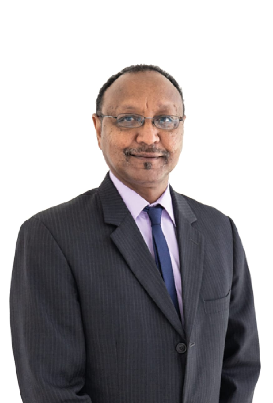
Dr. Abdelgadir Abuelgasim is an internationally recognized expert in remote sensing, geographic information systems (GIS), and environmental sciences. He currently serves as an Associate Professor at Rabdan Academy and Zayed Military University in the United Arab Emirates. With over 30 years of academic and research experience, he has held key positions at prestigious institutions such as Boston University, NASA Goddard Space Flight Center, and the Canada Centre for Remote Sensing. His research focuses on climate change, air quality, soil salinity, arid ecosystems, and satellite-based Earth observation. Dr. Abuelgasim has published extensively in peer-reviewed journals, led major research projects funded by national and international agencies, and supervised numerous master's and PhD students. He is a frequent speaker at international conferences and serves as a scientific reviewer for leading journals in the field. His expertise plays a critical role in advancing applied geoscience research, sustainable resource management, and innovative solutions for arid and semi-arid regions.
Keynote Title:
Image Processing and Computer Vision: Tools for a Smarter Earth
Professor Naeem Ramzan is an internationally recognized expert in artificial intelligence, computer vision, and multimedia processing. He currently serves as a Professor of AI and Computer Engineering at the University of the West of Scotland, where he also leads the Artificial Intelligence, Visual Communication, and Network Institute. With over 15 years of academic and research experience, he has played a key role in various EU-funded projects and previously held positions at Queen Mary University of London. His research spans video communication, affective computing, IoT, and digital health. Professor Ramzan has led several MSc programmes and supervised numerous postgraduate students. He actively contributes to the academic community as a Senior Member of IEEE, Fellow of the Royal Society of Edinburgh (FRSE), and Senior Fellow of the Higher Education Academy (SFHEA). His work advances cutting-edge applications in smart environments, remote sensing, and human-centered computing.
Keynote Title:
Mapping Carob Forest Dieback using UAV-Based Multispectral Data, Biomass-Chlorophyll Indices and
Machine Learning
Professor A. Bannari received a B.Sc. in Geodesy and Surveying Engineering from the Hassan-II Agronomic and Veterinary Institute (Rabat, Morocco), an M.Sc. in Geomatic and Analytical Photogrammetry from Laval University (Québec, Canada), and a Ph.D. in Remote Sensing form Sherbrooke University (Québec, Canada). He joined SPAR Aerospace Limited in Montreal (Quebec, Canada) as a researcher, where he worked on the conceptualization of small satellite sensors. He was a visiting scientist at the University of Arizona (Tucson), the Canada Center for Remote Sensing (Ottawa), and NASA’s-JPL (Pasadena, California). After retiring from the University of Ottawa (Ontario, Canada) as a Professor of Remote Sensing and GIS, he served as Chair of the Department of Geo-informatics at the Arabian Gulf University in the Kingdom of Bahrain. Professor Bannari has authored 2 books, 10 book chapters, and more than 275 articles, and has supervised over 64 graduate students. Currently, he leads Space Pix-Map International Inc., a private company based in Ottawa, Canada, providing international scientific consultations in remote sensing, geomatics, and environmental applications.
Title: Deep Learning for Satellite Imagery
Dr. Mohamed Biniz is affiliated with Sultan Moulay Slimane University (USMS) in Beni Mellal, Morocco, where he holds the title of Professor HDR (Habilitation à Diriger des Recherches). He is a member of the Traitement de l'Information et Aide à la Décision (TIAD) research laboratory at the university's Faculty of Sciences and Techniques. The TIAD lab focuses on areas such as image and signal processing, pattern recognition, artificial intelligence, data analysis, and decision support systems.

Title: Roadmap for Building Production-Ready Applications Using LLMs
Dr. Youssef Saadi is an Associate Professor (Professeur Habilité) in the Department of Computer Science at the Faculty of Sciences and Techniques (FST) of Sultan Moulay Slimane University (USMS) in Beni Mellal, Morocco. He joined the university in September 2018 and is actively involved in both teaching and research.
.jpg)
Title: Geospatial Data, Web Service and WebMapping
Dr. Hicham Mouncif is a full professor at the computer sciences departement in the Faculty of Polydisciplinary Studies of Sultan Moulay Slimane University in Beni Mellal, Morocco. He is actively involved in both academic and research activities within the university. His research interests include: security of geospatial web services, machine learning and IoT routing protocols,... etc.
Title: LiDAR Data Analysis with AI Algorithms
Dr. Bachaoui specializes in the use of LiDAR and AI for geospatial analysis. He is involved in several projects combining remote sensing with machine learning techniques.
Title: Drone-Based Remote Sensing: From Flight Planning to Data Analysis
Dr. Abderrazak El-Harti is a full professor in the Department of Earth Sciences at the Faculty of Sciences and Techniques of Beni Mellal, part of Sultan Moulay Slimane University in Morocco. He is renowned for his extensive research in remote sensing, GIS, mineral exploration, geological mapping, hyperspectral remote sensing, and precision agriculture.
| Category | Early Bird (by March 20, 2026) | Regular (after March 20, 2026) |
|---|---|---|
| USMS UNIVERSITY STUDENT | 1000 MAD (100$) | 1500 MAD (150$) |
| OTHER UNIVERSITE STUDENT | 1500 MAD (150$) | 2000 MAD (200$) |
| Academic | 2500 MAD (250$) | 3000 MAD (300$) |
| Industry | 3000 MAD (300$) | 3500 MAD (350$) |
| Poster | 700 MAD (70$) | 1000 MAD (100$) |
Please complete your registration by bank transfer using the following details:
| Bank Name | Crédit Agricole du Maroc |
|---|---|
| Bank Address | Agence Bancaire BENI MELLAL AIN ASSERDOUNE |
| Beneficiary Account Name | Intelligent Computing Center (ICC) Association |
| Beneficiary Account Number | 225090068903520651010732 |
| IBAN | MA64225090068903520651010732 |
| Swift Code | CNCAMAMRXXX |
| Currency | MAD |
| Reason for Transfer | ICAIGT 2026 Conference (essential for your registration) |
Submissions must be original, not have been published, and not under review elsewhere for publication. All papers will undergo a thorough double-blind peer-review process conducted by a distinguished panel of experts to ensure the highest standards of academic and technical quality.
The authors may choose one of the two following options for their submissions :
SUBMIT YOUR PAPER BY LOGGING ONTO THE FOLLOWING WEBSITE: https://submission.icaigt.com
Below is the official conference schedule. All times are local (UTC+01:00).
| Time | Session | Details |
|---|---|---|
| 09:00 – 10:00 | On-site Registration | Participant registration and welcome. |
| 10:00 – 11:30 | Opening Ceremony |
• M. Khalid Mehdi, Interim President of Sultan Moulay Slimane University, Beni Mellal, Morocco • M. Muhammad Kamran, Vice Chancellor of The Islamia University of Bahawalpur, Pakistan • M. Abderrazak El Harti, General Chair of ICAIGT 2026, Dean of the Polydisciplinary Faculty, Beni Mellal, Morocco • M. Ahmed Barakat, Dean of the Faculty of Sciences and Technics, Beni Mellal, Morocco |
| 11:30 – 12:00 | Tea & Coffee Break | Networking break. |
| 12:00 – 13:30 | Plenary Session 1 |
“Mapping Carob Forest Dieback using UAV-Based Multispectral Data, Biomass-Chlorophyll Indices and Machine Learning” By Dr. Abderrazak Bannari (Québec, Canada) |
| 13:30 – 15:00 | Lunch Break | Lunch and networking. |
| 15:00 – 16:20 | Session 1 |
Natural Resource Management and Geospatial Intelligence Conference Amphitheater – FSTBM Chair: Pr. Muhammad Kamran • ID #57 - Mapping Barite mineralization using fused spectral methods and Sentinel-2 data in Eastern Anti-Atlas — Zakaria Adiri • ID #110 - Integrating Machine Learning and Multi-Criteria Spatial Analysis for Sustainable Geotourism Site Selection in Fragile Karst Environments: A Case Study of the Amekla Plateau (Central Middle Atlas) — Chami Jaouad • ID #113 - Vertical Variation of Soil Organic Carbon Stock: Integrating Process-Based Understanding — Hassan Mosaid • ID #115 - Performance Assessment of Microbial-Based Biostimulants and Organic Amendments in Winter Wheat Using Spectral-Thermal Fusion and Temporal Density Analysis — Lahoucine Ech-Chatir |
| 16:20 – 19:00 | Session 2 |
Remote Sensing and Earth Observation Analytics Conference Amphitheater – FSTBM Chair: Pr. G. H. Abbasi (16:20–17:40) • ID #59 - The contribution of multispectral drones to precision agriculture in the Tadla Plain (Morocco): efficiency, advantages, and challenges — Hasna Jinnou • ID #61 - Integration of Sentinel-2 imagery and machine learning models for high-resolution mapping of soil macronutrients in irrigated perimeters in semi-arid areas — Yassine Amrouss • ID #91 - Proposal of a New Method for Considering Olfactory Nuisances in Public Landfill Siting in Morocco — Moussaif Bouchta • ID #95 - Assessing Short-Term Soil Salinity Dynamics in Semi-Arid Landscapes Using Proximal Sensing and Ensemble Learning — Mongai Joyce Chindong Chair: Pr. A. Bannari (17:40–19:00) • ID #10 - Integrating NDVI Time Series and Climate Data to Evaluate Olive Tree Responses to Climate Change in Béni-Amir — Ayoub Daiz • ID #100 - A Comparative Assessment of Deep Learning Approaches for Semantic Segmentation of Plant Species Using High-Resolution UAV Imagery in a Mountainous Environment — Sani Amadou Mahamadou Mansour • ID #103 - Integrating Optical-Microwave Scintillometry with the SPARSE Model for Landscape Scale Evapotranspiration Monitoring in a Drip Irrigated Olive Orchard — Barguache (Online) • ID #117 - Vegetation Dynamics in Al Hoceima National Park (Morocco) Assessed Using Remote Sensing and Machine Learning — Alae Mouddou |
| 16:20 – 19:00 | Parallel Session 2 |
Remote Sensing and Earth Observation Analytics Classroom A Chair: Pr. T. Tagma (16:20–17:40) • ID #55 - Advanced Euphorbia resinifera Detection for Sustainable Semi-Arid Ecosystem Management: A Comparative Deep Learning Analysis Using UAV Imagery — Ilias Jennaoui • ID #58 - Spatiotemporal assessment of citrus orchard health in Morocco Tadla plain using Sentinel-2 biophysical indices (2019–2024) — El Atiq Jaouad • ID #66 - Combined Forest Pressure Index (CFPI) for Spatial Diagnosis of Ecological and Anthropogenic Pressures in Semi-Arid Mediterranean Forest Ecosystems — Diouane Fatima • ID #74 - High-Resolution Land Surface Temperature Downscaling Using MODIS–Sentinel Data Fusion Over Semi-Arid Wheat Fields — Zainab Bouswir • ID #75 - Spatiotemporal Evaluation and Hyperspectral Modelling of Mudflat Gross Primary Production in France Estuarine Environments — Hajar Saad El Imanni Chair: Pr. F. Shahzad (17:40–19:00) • ID #77 - Monitoring Spatiotemporal Variability of Agricultural Drought Using VCI, TCI, and VHI Derived from Satellite Time Series — Rachida Guendour • ID #83 - Spatio-temporal analysis of forest dynamics in the Upper Oued El Abid watershed (High Central Atlas, Morocco) using remote sensing techniques — Yassine Eljaouhary • ID #85 - Advances and Future Directions in Remote Sensing Methods and Platforms for Sustainable Monitoring of Forest Degradation — Mohamed Chikh Essbiti • ID #9 - Assessing forest cover changes in Khenifra National Park (Middle Atlas, Morocco) using remote sensing — Salwa Mokrane (Online) • ID #90 - Influence of slope on sheet runoff erosion in the upper Sissili watershed (Burkina Faso) — Augustin Yameogo (Online) • ID #93 - Remote Sensing Pathways for Groundwater Depletion Assessment in Data-Scarce Irrigated Basins: Methodological Evaluation and Application to Morocco — Dakir Asmae • ID #99 - Mapping and prediction of soil salinity using Sentinel-2 imagery and machine learning models in the Tadla Plain (Morocco) — Abdessamad Hilali |
| Time | Session | Details |
|---|---|---|
| 08:30 – 09:30 | Plenary Session 2 |
“An overview of the scientific research advances on agricultural soils in Pakistan for sustainable exploitation.” By Dr. Hassan Ghulam Abbasi (The Islamia University of Bahawalpur, Pakistan) |
| 09:30 – 10:00 | Tea & Coffee Break | Networking break. |
| 10:00 – 14:00 | Session 3 |
GeoAI and Big Data Analytics Conference Amphitheater – FSTBM Chair: Pr. F. Shahzad (10:00–11:20) • ID #14 - Citrus Canopy Segmentation from UAV Imagery Using U-Net and Morphological Processing: Application to a Citrus Orchard in Beni Mellal–Khenifra Region, Morocco — Daiaeddine Mohamed Jibril • ID #5 - AI-Driven Flood Susceptibility Modeling Using Geospatial Big Data: A Case Study of the Loukkos Watershed, Morocco — Coulibaly Demba • ID #6 - Temporal Deep Learning for Land Cover Dynamics: A 1D-CNN Approach to Analysis and Prediction — Rkia Bendaoud • ID #63 - The seasonal mapping land surface temperature using Landsat 8 OLI/TIRS thermal remote sensing data: A case study of Beni Mellal city, Morocco — Moha Errachdi Chair: Pr. H. Mouncif (11:20–14:00) • ID #78 - Spatio-Temporal Forecasting of PM2.5 in Bahawalpur, Pakistan Using Graph Neural Networks and Multi-Variate Transformers — Rameez Farooq • ID #79 - GeoAI-Based Cross-Sensor Fusion for Cloud-Free PRISMA and EnMAP Hyperspectral Reconstruction — Ghizlane El Guerch • ID #81 - Flood susceptibility mapping using unsupervised learning: A case study in the city of Tata, Morocco — Assia Erguigue (Online) • ID #76 - Spatial Modeling of Gully Erosion in Semi-Arid Mountain Environments Using Machine Learning Models — Oussama Nait-Taleb |
| 14:00 – 15:30 | Lunch Break | Lunch and networking. |
| 15:30 – 16:15 | Session 4 |
Digital Twins and Smart Environment Monitoring Conference Amphitheater – FSTBM Chair: S. El Ghmari • ID #105 - Heritage Valorization: Contribution of Laser Scanning to the Conservation of Historical Monuments in Béjaâd — Ahanssal Chaima • ID #65 - Multisensor UAV Integration in Civil Engineering Projects — Toufik Enfissi • ID #69 - The Role of IoT and Edge Computing in Digital Twin: Sensors, Data Collection, and Real-Time Monitoring — Rotimi-Williams Bello (Online) |
| 16:15 – 17:45 | Session 5 |
GeoAI and Big Data Analytics Conference Amphitheater – FSTBM Chair: I. Aattouri • ID #102 - GeoAI-Based Assessment of Pesticide Use Practices and Associated Health Risks among Farmers in the Tadla-Azilal Region, Morocco — Ouardi Fatima Zohra • ID #104 - Machine Learning-Based Lithological Mapping from Sentinel-2 Imagery in the Moroccan High Atlas: A Random Forest Approach — Zaina El Kamel • ID #106 - Theoretical Roadmap for Building an Intelligent Geomorphological Knowledge Base Using Large Language Models — Mohamed En-Nejmymy • ID #112 - Binary Classification of Fire and No-Fire Images Using Convolutional Neural Network — Aziz Akermoud • ID #114 - Rockfall Susceptibility Mapping Using GeoAI and Machine Learning: El Harrar Watershed (Eastern Pre-Rif Hills, Morocco) — Bahija Filal • ID #13 - Establishment of a conceptual framework to detect automatically the urban planning offences using Deep Learning and RGB orthophotos: study case of Morocco — Mohamed Mellaki |
| 17:45 – 19:00 | Workshop | Workshop session. |
| 19:00 – 20:00 | Closing Ceremony | Official closing of ICAIGT 2026. |
Faculté Polydisciplinaire - Université Sultan Moulay Slimane
Mghila, BP: 592 Beni Mellal, Morocco
Tel: +212 (0)5 23 42 46 85 / 16
Fax: +212 (0)5 23 42 45 9


 The Islamia University of Bahawalpur

Innovation in Mathematics and Applications and Information Technologies Laboratory